| Country of Origin | United States |
|---|---|
| PID | 869851 |
| Product depth (mm) | 30 |
| Product height (mm) | 170 |
| Product weight (g) | 246 |
| Product width (mm) | 205 |
| Display resolution | 1280 x 800 |
| Display size (inches) | 8 |
| Electronic address of single contact point | |
| Manufacturer address | "GARMIN Corporation, Street: No.68 Zhangshu 2nd Rd, Xizhi Dist, Postcode:221, City: New Taipei City 221, Country: TAIWAN, R.O.C / GARMIN Würzburg GmbH, Street: Beethovenstraße 1 a+b, Postcode: 97080, City: Würzburg, Country:Germany " |
| Manufacturer's email address | |
| Manufacturer name | GARMIN Corporation / GARMIN Würzburg GmbH |
| EU Responsible Person | GARMIN Würzburg GmbH, Street: Beethovenstraße 1 a+b, Postcode: 97080, City: Würzburg, Country:Germany |
With the maps of this durable motorsport navigator, you stay on track, and its communication technology keeps connections while you are on the move.
Key features:
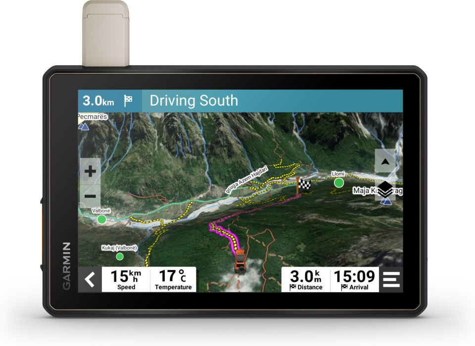
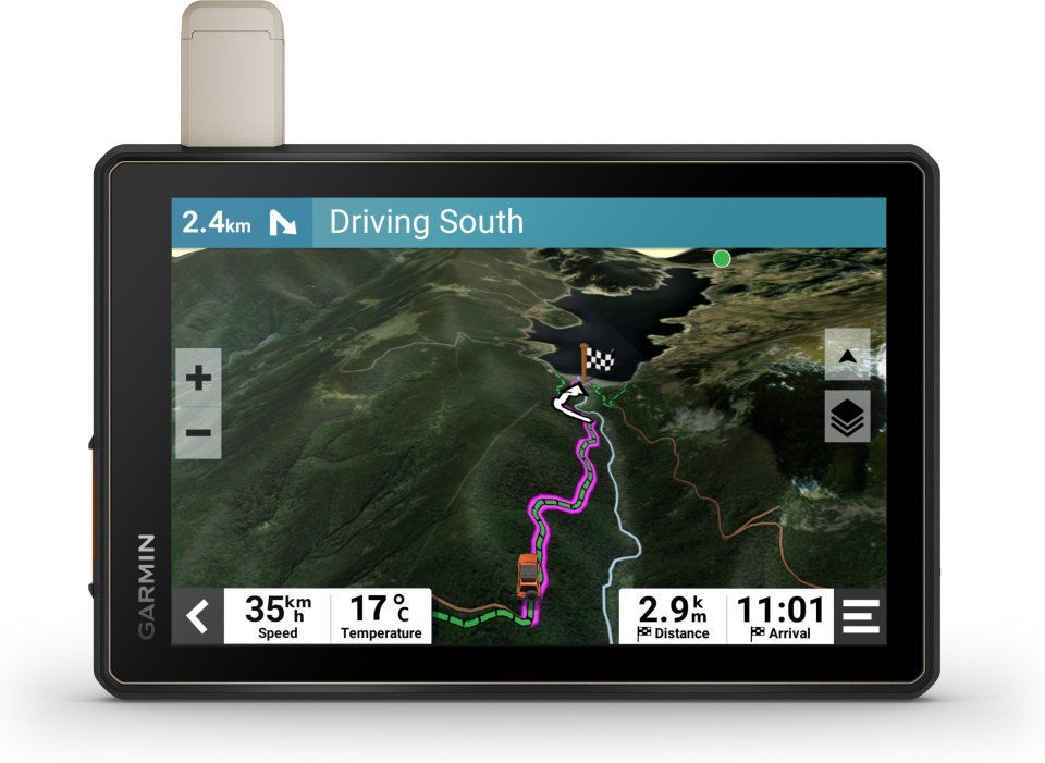
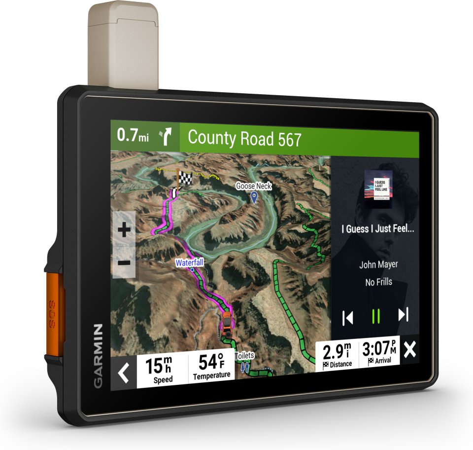
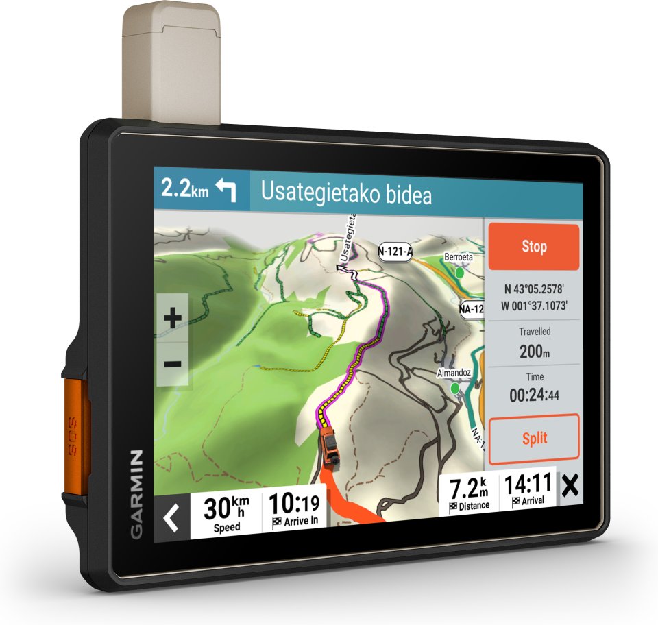
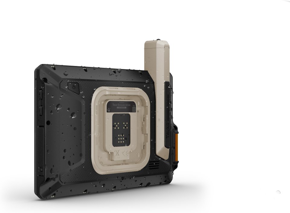
The navigator’s extremely bright 8″ glove-friendly touchscreen ensures excellent visibility in both bright sunlight and complete darkness. It can be mounted in portrait or landscape orientation.
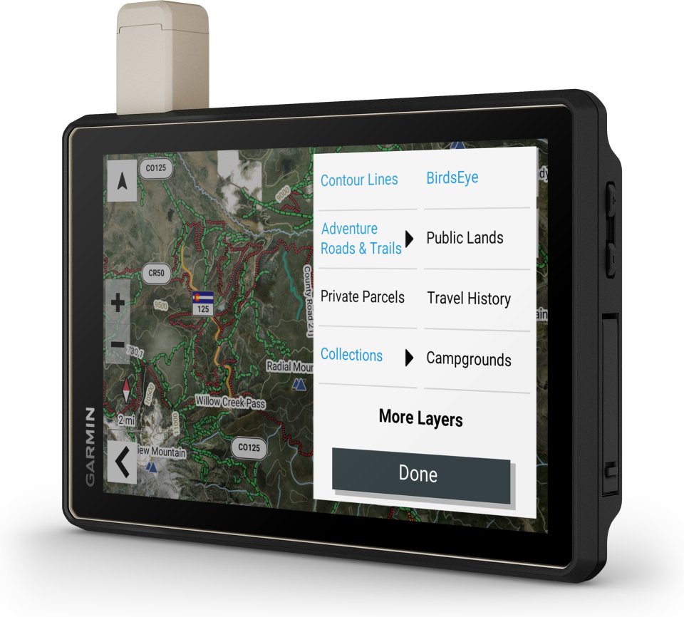
With turn-by-turn navigation, you can travel on unpaved roads and trails using adventure roads and trails map content based on OSM maps.
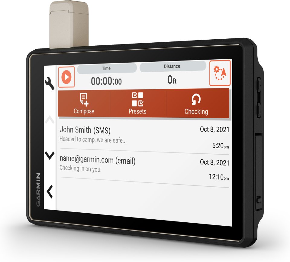
Built-in inReach technology offers worldwide satellite communication, two-way text messaging, location sharing, interactive SOS function, and weather updates.
Tread comes preloaded with topographic maps of Europe, Africa (including Tracks4Africa), and the Middle East, featuring 3D terrain and street maps. It also includes detailed street maps of Europe and routing customized based on vehicle size and weight2. Maps of North and South America, Australia, and New Zealand are available for free download at garmin.com/express.
By downloading precise BirdsEye satellite images directly to the device via Wi-Fi®, you get access to vivid aerial photos without an annual subscription.
Tread includes preloaded iOverlander points of interest as well as ACSI™, Campercontact™, and Trailer’s PARK™ data, so you don’t need mobile signal when searching for the best campsites, even if they are remote or scattered.
Especially in difficult terrain, it is convenient to use built-in sensors such as altimeter, barometer, compass, as well as pitch and roll sensors.
Attach the navigator to your vehicle with the included lockable magnetic mount.
By pairing the device with the Tread app, you can track your friends from your phone using the Group Ride Mobile feature.
With the Tread app, you can easily plan routes using the same maps, vehicle profiles, and route settings as on the Tread device.
The Tread app allows you to sync waypoints, tracks, routes, and collections across all your devices. You can also easily import and share GPX files.
What’s the weather? By pairing the Tread device with a compatible smartphone and downloading the Tread app, you get access to real-time weather information, storm alerts, and animated radar.
Pair Tread with a compatible digital Garmin PowerSwitch™ control box (sold separately) and control your vehicle’s 12-volt electrical devices – such as light bars and differential locks – from the navigator’s screen.
By pairing the device with a compatible Group Ride Tracker device (sold separately), you can use group tracking5 and preset messages.
By wirelessly pairing Tread with certain Garmin GPS dog devices (sold separately), you can track and locate dogs in the field. You see each dog’s marker within the tracking area directly on the navigator’s map screen.
Technical specifications:
Package contents:
With the maps of this durable motorsport navigator, you stay on track, and its communication technology keeps connections while you are on the move.
Key features:
The navigator's extremely bright 8″ glove-friendly touchscreen ensures excellent visibility in both bright sunlight and complete darkness. It can be mounted in portrait or landscape orientation.
With turn-by-turn navigation, you can travel on unpaved roads and trails using adventure roads and trails map content based on OSM maps.
Built-in inReach technology offers worldwide satellite communication, two-way text messaging, location sharing, interactive SOS function, and weather updates.
Tread comes preloaded with topographic maps of Europe, Africa (including Tracks4Africa), and the Middle East, featuring 3D terrain and street maps. It also includes detailed street maps of Europe and routing customized based on vehicle size and weight2. Maps of North and South America, Australia, and New Zealand are available for free download at garmin.com/express.
By downloading precise BirdsEye satellite images directly to the device via Wi-Fi®, you get access to vivid aerial photos without an annual subscription.
Tread includes preloaded iOverlander points of interest as well as ACSI™, Campercontact™, and Trailer’s PARK™ data, so you don’t need mobile signal when searching for the best campsites, even if they are remote or scattered.
Especially in difficult terrain, it is convenient to use built-in sensors such as altimeter, barometer, compass, as well as pitch and roll sensors.
Attach the navigator to your vehicle with the included lockable magnetic mount.
By pairing the device with the Tread app, you can track your friends from your phone using the Group Ride Mobile feature.
With the Tread app, you can easily plan routes using the same maps, vehicle profiles, and route settings as on the Tread device.
The Tread app allows you to sync waypoints, tracks, routes, and collections across all your devices. You can also easily import and share GPX files.
What’s the weather? By pairing the Tread device with a compatible smartphone and downloading the Tread app, you get access to real-time weather information, storm alerts, and animated radar.
Pair Tread with a compatible digital Garmin PowerSwitch™ control box (sold separately) and control your vehicle’s 12-volt electrical devices – such as light bars and differential locks – from the navigator’s screen.
By pairing the device with a compatible Group Ride Tracker device (sold separately), you can use group tracking5 and preset messages.
By wirelessly pairing Tread with certain Garmin GPS dog devices (sold separately), you can track and locate dogs in the field. You see each dog’s marker within the tracking area directly on the navigator’s map screen.
Technical specifications:
Package contents: